Portfolio
Projects to develop the future
ORCA-1 Well, Guajira, Colombia
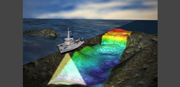
We performed this study using our high resolution SSS/MAG solution at 650 meters water depth. Once the anomalies were identified we utilized our ROV to investigate the seabed. The drilling permits were granted. In October 2014, PETROBRASS announced that they found gas, making it the deepest discovery offshore Colombian waters.
REPSOL RC-11, Guajira, Colombia
Environmental and geophysical studies to drill exploratory wells in a 40 square kilometers area offshore Guajira, Colombia. Used our high-resolution Side Scan Sonar at 300 y 900 KHz coupled to our high sensitivity magnetometer. The principal anomalies were investigated using our ROV taking video and pictures that were analyzed by our scientific team.
ORCA-1 Well Post Drilling Video, Colombia
Once Petrobras perforated the ORCA-1 exploratory well and to comply with Colombian government regulations a video inspection of the 2-kilometer diameter circle centered at the well was done utilizing an ROV with a fiber optic umbilical equipped with our Applied Acoustics NEXUS USBL, high-definition video camera and forward-looking sonar to visualize the seabed status after the drilling operations.
Turks and Caicos, Phase I
Geophysical and hydrographic survey was done in Providenciales under contract with Exxon-Mobil. Trained Exon Interns in the techniques of sub-bottom profiling and generated 3D images of the sediment. The scientific data was presented at “American Association of Petroleum Geologists”, AAPG, 2007 meeting in a paper “Integrated CHIRP and Water Bottom Sediment Sampling Across a Modern Carbonate Platform, Turks and Caicos, BWI”.
Turks and Caicos Phase II
We performed this
study using our high resolution SSS/MAGsolution at 650 meters water depth. Once
the anomalies were identified we utilized our ROV to investigate the seabed.
The drilling permits were granted. In October 2014, PETROBRASS announced that
they found gas, making it the deepest discovery offshore Colombian waters.
REPSOL RC-11, Colombia
Environmental and
geophysical studies to drill exploratory wells in a 40 square kilometers area
offshore Guajira, Colombia. Used our high-resolution Side Scan Sonar at 300 y
900 KHz coupled to our high sensitivity magnetometer. The principal anomalies
were investigated using our ROV taking video and pictures that were analyzed by
our scientific team.
Environmental Studies: solving complex problems
Study and Characterization of the Gulf Stream
Since 2012 have a contract with NOAA (National Oceanographic and Atmospheric Administration) to assist in their monthly studies along Latitude 27 from West Palm Beach, FL. to West End, Bahamas crossing the Gulf Stream taking data profiles of the water column at 9 pre-determined stations assisting NOAA personnel.
Schooner Shoals Project, Eleuthera, Bahamas
Under contract with the National Science Foundation and Dr. Gene Rankey from the University of Kansas, we realized the study: “Geomorphic Evolution and Heterogeneity of Holocene Carbonate Tidal Sand Shoals” utilizing our GeoCat technology and our Shallow water survey vessel Ooid in Schooner Shoals, Bahamas.
Lilly Bank, Bahamas
In Collaboration With Dr. Gene Rankey From the Marine Geology Department
of the University of Miami at RSMAS, and under contract with the
National Science Foundation, a geophysical and Hydrographic study of the
Lilly Bank was done to complement our previous studies of the area in
the dynamic processes of sediment transport.
Walkers Cay, Bahamas
Exxon-Mobil in cooperation with Dr. Gene Rankey, a comprehensive geophysical survey of the area in the vicinity of Walkers Key was done utilizing our GeoCat technology including our CHIRP and our Applied Acoustic Boomer. As survey platform utilized our geophysical research vessel “Ooid”. We collected lines starting at 50 Centimeters water depth and ending at 600 meters to have a complete characterization of the area.
Little Bahama Bank, Bahamas
In cooperation with Dr. Gene Rankey of the University of Miami as part of his ongoing scientific research on Ooids and marine sediment transport, we used GeoCat technology with our CHIRP Sub-bottom Profiler to study the shallow banks of Lily Bank, The Horse, Strangers Key, Walkers Cay and surrounding waters.
Coral Reefs, St. Croix, Virgin Islands
In cooperation with the US National Park Service personnel and with Dr. Pam Reid’s University of Miami Team acquired data and produced Maps and coral reef mosaics in the National Underwater Marine Park in St. Croix utilizing the Diver Held Coral Reef Mapper designed by Bert Instruments for Professor Reid.
Coral Reefs in the Florida Keys
Coral Reef mapping of several sites in the Florida Keys to test and produce mosaics utilizing the Diver Held Coral Reef Mapper designed for Dr. Pam Reid of the University of Miami under contract with SERDP/U.S. Department of Defense to complement the ROV mapping system designed in 2006.
Coral Reef Mapper Design/Construction
Developed the hardware systems utilizing high definition video and synchronized still photography for a diver-held system to create mosaics of the coral reefs for Dr. Pam Reid of the University of Miami. This design was part of the 2009 project of the year from SDERP, Department of Defense awarded to Dr. Reid and her team.
Projects to develop the future
Pipeline Location Yellowstone River
Due to an increase of the water flow of the Yellowstone River in Montana the Silvertip pipeline broke down creating an environmental disaster. Bert Instruments assisted Conoco-Phillips lo locate the pipeline depths and sediment cover in four of their pipelines adjacent to the Silvertip pipeline.
Bear Cut Pipeline Planning, Miami, Florida
As part of the University of Miami upgrading of their aquaculture facility at the RSMAS Campus, a new intake buried pipeline to collect seawater filtered trough the sediment is being designed. We provided hydrographic and sub-bottom surveys and produced precise bathymetric maps and sub-bottom sediment profiles to aid in the design.
RV Ancon Echosounder, Colombia
Provided and installed a full ocean depth Knudsen echosounder/sub-bottom profiler on the RV Ancon, the research vessel of the INVEMAR (Institute of Marine Research) in Punta Betín, Santa Marta, Colombia. We designed an installed in dry dock the acoustic blister to house the transducers and trained the institute scientists in their operation.
Burlington Bridge, Iowa
This train bridge built in the 1800’s to join Chicago and Detroit was being upgraded to allow the transit of larger ships over the Mississippi River. While laying the foundation of the new pilings it was found a large quantity of buried debris, metallic and non metallic, that was interfering with the pilings construction and damaging the drilling system. We provided very high-resolution sub-bottom profiles used to identify an accurately located this hazards. Based in our results the pilings were re-designed.
Invemar CTD, Santa Marta, Colombia
We provided a state of the art CTD with titanium housing, and a water sampling Rosette with additional fluorometer and dissolved oxygen capabilities in depths up to 7,000 meters to the Institute of Marine Research, INVEMAR in Punta Betín, Santa Marta, Colombia. Installed the equipment on board the Institute Research Vessel R/V. Ancon, and trained the scientific personnel both in theory and practical data acquisition.
Shallow Water Survey, Colombia
This study was part of the World Bank project “Emisario Submarino de Cartagena” managed by the utilities department of Cartagena, ACUACAR. A comprehensive survey utilizing our sub bottom profiler mounted in the GeoCat, Side Scan Sonar, a precise bathymetric survey and ROV inspection of relevant anomalies over the proposed pipeline track carrying the treated sewage 3.5 Km into the Atlantic over possible mud diapirs in this volcanic zone.
Venetian Pipeline Planning, Miami, FL.
Prior to the directional drilling and installation of the sewage pipeline between mainland Miami and Watson Island along the Venetian Causeway Bridge, Bert Instruments under contract with Hazen and Sawyer surveyed the area using GeoCat Technology to produce sediment distribution maps and key sub bottom features to aid in the planning of the directional drill route. The results were presented at WEFTEC 2003 in Los Angeles in a paper “Tunneling 2,500 feet of Pipe Under Biscayne Bay”
Guayanilla Bay Survey, Puerto Rico
Sub bottom survey using GeoCat technology in Guayanilla Bay, Puerto Rico. The geophysical studies are to be used in offshore dredging planning, design of the pier area and the filling of a shallow area for container storage. The shallow area to be filled varied in depths from 2 ft. to 10 ft. The planned pier construction area was at a 50 ft. water depth with a sediment penetration of 165 ft. Sediment distribution and thickness maps were produced to aid in the engineering design.
Ponce Harbor Survey, Puerto Rico
Sub bottom survey using GeoCat technology in Ponce Harbor, Puerto Rico. The area of the existing port facilities, existing channel and general surroundings was surveyed to produce geological maps of the area in water depths varying from 2 ft. to 90 ft. This study was done as part of the feasibility studies prior to the offshore dredging prior to construction of the Ponce Harbor Mega Port.
Key Biscayne Beach Renourishment
Sub-bottom survey in very shallow water (2-20 ft.) utilizing GeoCat technology to identify, map and quantify sand deposits and to locate submerged cultural resources as part of the Key Biscayne, Fl. Beach renourishment project as sub contractor for Coastal Systems International.
Santa Maria Marina, Miami. FL
With underwater archaeologist Dr. John Gifford. Very shallow water pre-construction bathymetric, sub bottom and metal detector survey to locate “solution holes” and investigation of magnetic anomalies in search of submerged cultural resources along the west central coast of Biscayne Bay. Used GeoCat technology, marine magnetometers and metal detectors.
Illyrian Underwater Survey, Albania
On board the R.V. Millbrook with Dr. John Gifford from the University of Miami, conducted a multisensor search of the Albanian coast utilizing a Side Scan Sonar, ROV and Magnetometer
Buried FPL Power line, Hollywood
Under contract with MRI surveyed the planned FPL cable directional drilling route under the Intercostal waterway using our GeoCat technology.
New Port, Freeport Bahamas
Under contract with Continental Shelf Associates, utilized the GeoCat technology to identify sub-bottom features anomalies in the feasibility study for the new port close to Freeport, Bahamas.
Berry Islands U.S. Navy Cable, Bahamas
In a joint effort with Perigee, Inc. provided to the U.S. Navy the multi beam and sub-bottom profiler studies needed to define the best route for a submerged cable crossing and best cable anchoring schemes.
Punta Canoas Survey in Cartagena, Colombia
A sub bottom profile survey of the proposed 3.5 Km pipe tract that is to be buried in the sediment as part of the Cartagena, Colombia, sewage treatment system was done as sub contractor of Hazen and Sawyer and Marine Resources Inc. Data post processing included a comprehensive core-seismic calibration study integrating the acoustic sensors data with 18 boreholes, interpretative line drawings focused on key subsurface features, detailed figures showing the calibration of core borings to seismic facies, and a series of isopachous and contour maps that clearly illustrate the extent of the subsurface units. The study was part of the feasibility study conducted by Hazen and Sawyer in this World Bank project.
Miami Beach Main Sewage Pipeline, Miami, FL
While driving new pilings in the south edge of the Miami Beach Marina, the contractor penetrated the main sewage line running between Miami Beach and the sewage treatment plant in Fisher Island creating an ecological and economic disaster in the area.Some contractors tried to locate the pipeline but failed. Miami Dade Water and Sewage Department commissioned Bert Instruments to survey the Miami Beach Marina and the Government Cut Channel locate the buried pipeline and create a set of drawings certified by a Florida Registered Surveyor. Bert Instruments, using the GeoCat, was able to locate the pipeline and certify its position with great accuracy.
Finding History
Key Biscayne Magnetometer Survey
As sub contractor for Coastal Systems International in the Key Biscayne beach renourishment project a shallow water high-resolution magnetometer survey of the proposed sand borrow areas was conducted to determine the presence of cultural submerged resources in compliance with Federal and State ordinances.
Soldier Key Shipwreck, Key Biscayne, FL
Sub-bottom survey of the old shipwreck located 5 miles south of Key Biscayne, FL for the National Park Service in water depths between 3 to 15 ft. Different sub-bottom anomalies were processed to create a probability distribution map of targets to locate and visualize additional shipwreck remains.
Archaeological Studies, Key west, Florida
The company CGS has a permit to search for underwater-submerged resources in the area of Key West, Florida. We provided sub-bottom profiler services to locate sub-bottom anomalies and generate accurate sub-bottom maps identifying the amounts of sand up to bedrock to complement their magnetometer studies in the search for a Spanish Galleon of the Atocha Fleet.
SBP survey of the Montecristi shipwrecks
In the northern Dominican Republic. Sub-bottom survey with North Caribbean Research, using GeoCat technology, marine magnetometer and metal detector to locate shipwrecks and submerged cultural artifacts of historical value in the Montecristi area.
Little Salt Spring, Florida
Underwater archaeological project in West Florida with Dr. John Gifford in search of buried Paleo-Indian features in the spring basin, using the RovBert, a specially modified Phantom HD2+2 ROV, marine magnetometer and metal detector. We have been involved in this continuing project since 1993.
Santa Maria Marina, Miami. FL
With underwater archaeologist Dr. John Gifford. Very shallow water pre-construction bathymetric, sub bottom and metal detector survey to locate “solution holes” and investigation of magnetic anomalies in search of submerged cultural resources along the west central coast of Biscayne Bay. Used GeoCat technology, marine magnetometers and metal detectors.
Actium Project, Greece
With Dr. Bill Murray from the University of South Florida and Dr. John Gifford from the University of Miami, conducted a Side Scan Sonar search of the waters in the vicinity of Preveza to pinpoint the location of the Actium Battle where the Roman Navy defeated Marc Anthony and Cleopatra.
Jupiter Wreck, Florida
Sub-bottom profiler of the unidentified Spanish Galleon off Jupiter Inlet, FL. To assist in the location of Solution holes and data acquisition to visualize the debris distribution using our Geo-Cat system producing a tri-dimensional maps of sediment units.
Key West Spanish Galleon, Florida
CGS, Inc. has the permits to search for submerged cultural resources in the vicinity of Key West, Florida. Bert Instruments provided its sub-bottom profiler expertise to quantify and map the overburden in search of solution holes to complement their magnetic and satellite data in search of a Spanish Galleon.
Broward County Archaeological Investigation, Florida
This study is part of the Broward County, Florida, beach renourishment project. Magnetic anomalies in the Broward County burrow areas and its vicinity were studied utilizing our ROV, magnetometer, metal detector and our team of underwater archaeologist divers. Each site was documented using our high-resolution ROV video camera, a hand held underwater video camera and still photography.
Port Royal Sunken City Mapping, Kingstone, Jamaica
As part of the Port Royal Development Project, Bert Instrumentswas commissioned to map the sunken city of Port Royal, in Kingston, Jamaica, buried under the sand after the 1692 earthquake. The high-resolution sub bottom survey of the sunken city included the mapping of old structures buried in the sediment and the sub bottom survey of the proposed site for the Cruise Ship pier. The survey was done utilizing Bert Instrumentsproprietary GeoCat technology that allows the generation of high-resolution images in very shallow water.
Sub-bottom survey of the Montecristi shipwrecks, Dominican Republic
In the northern Dominican Republic. Sub-bottom survey with North Caribbean Research, using GeoCat technology, marine magnetometer and metal detector to locate shipwrecks and submerged cultural artifacts of historical value in the Montecristi area.
Hernando Archaeological Beach Multi-Sensor Survey, Florida
As part of the archaeological studies prior to the modifications to the Hernando Beach Channel, Bert Instruments was awarded the contract for a multi sensor survey of the existing channel and the proposed area for the new channel in a water depth varying between 2 ft. to 6 ft. A combination of precision fathometer, high sensitivity magnetometer, GeoCat sub bottom profiling system and precise satellite positioning was utilized with all the instruments acquiring data simultaneously with real time offsets to log always at the same geographical position in spite of the geometry of the array of instruments utilized.
Sharing knowledge
Everyone has a different learning style: some learn by doing, some by listening, and others by reading. Bert Instruments encourages and respects all forms of diversity in the learning environment. Our blended approach utilizes all of these techniques while at the same time capitalizing on the benefits of both instructor-led environments and eLearning efficiency.
Bert Instrument has always succeeded providing education around the world to some of the most important organizations, from the miltary to oil industries. Theory or hands on practice our main goal is to provide an extensive understanding of the knowledge we have gathered though more than 30 years of expertise.
Geophysical Training PDVSA, Maracaibo, Venezuela
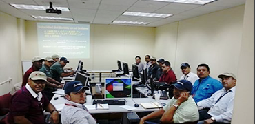
Trained the scientific personnel of the Venezuela Petroleum Company, PDVSA in the theory, acquisition and processing of geophysical data in the Maracaibo Lake. It was a three week, 120 hours intensive class at the PDVSA installations in Ciudad Ojeda in the Lake Maracaibo with numerous field trips to different sectors of the lake to visualize the extensive pipeline network using Edge Tech SSS and SBP.
Geophysical Training, Guayaquil, Ecuador
Trained the scientific personnel of INOCAR, part of the Ecuador Navy in the theory, acquisition and processing of Geophysical data in the ocean. It was a two-week, 80 hours intensive class at the INOCAR installations in Guayaquil, Ecuador. For the hands on part we used their EdgeTech SSS+SBP combined system along with their 4200 CHIRP Multi-Ping SSS.
Also we have developed specific specialized training on CTD’s Echosounders and other hardware.
Excellence is an art won by training and habituation
Aristotle
The best brands available
Applied Acoustic Engineering is a leading company in the design and manufacture of a wide range of subsea navigation and positio ning products, and marine seismic survey equipment.
The extensive product range includes the innovative USBL tracking system, Easytrak, a variety of positioning and release beacons and seismic sub-bottom profiling equipment for offshore geotechnical and seabed analysis.
EdgeTech is a leading manufacturer of underwater technology solutions. The company is known worldwide for its high quality products which include: side scan sonars, sub-bottom profilers, bathymetry systems, AUV and ROV-based sonar systems, combined and customized solutions. In addition to the full line of underwater survey products, EdgeTech provides reliable USBL systems, transponder beacons, deep sea acoustic releases, shallow water and long life acoustic releases, MRUs and customized underwater acoustic command and control systems.
Knudsen Engineering Limited (KEL), is located in Canada and has been designing and building echosounders for most of its existence. Starting in the late 1980’s with the 320A, designed for helicopter surveys in the high Arctic, and continuing with the 320M, 320B and their derivatives, Knudsen echosounders are now used in more than 60 countries around the world. Known for their pioneering use of digital signal processing (DSP) technology, Knudsen sounders are used in a wide range of applications, from shallow-water hydrographic survey to full-ocean depth scientific research.
GENERAL OCEANICS, INC. was established in Miami, Florida in 1966. From inception, the company’s goal has been to design and manufacture the highest quality instrumentation and water sampling products available to the oceanographic community. Aggressive research by our highly competitive staff has resulted in a product line with an outstanding reputation in the field.